

Celebrating India’s 2nd National Space Day: Releasing the Lunar Data Explorer
On the occasion of the second anniversary of India’s historic lunar landing, I’m excited to present a cloud-optimized Lunar Data Explorer.

A Prelude.
I’ll be honest: balancing a full-time day job with non-paid yet deeply fulfilling work is tough. It was two years ago, on the eve of India’s biggest achievement of the decade, that I found my passion for publicly sharing the work I’d quietly pursued outside of my daily grind reawakened.
India rightfully declared the day Chandrayaan-3 touched down at Shiv-Shakti Point as “National Space Day” for posterity. To me, it marked the day I rekindled my own curiosity—and what followed has been quite a journey. I launched this blog, dove deeper into lunar imagery, and started analyzing it using whatever techniques I picked up over the years. Whenever time allowed, I’d share insights, and almost incidentally, I wound up being the first to spot Japan’s SLIM lander and, more recently, Intuitive Machine’s Athena in archival data released by ISRO at ISSDC.
People often ask how I manage to do what I do. Some think it must be easy. Admittedly, it’s gotten somewhat “easy” for me now. Still, despite the many tools I’ve personally cobbled together to make my life a tad simpler (because ISRO, for reasons best known to them, refuses to open-source their own tooling—though they often benefit from others that do!), it always comes back to good old manual effort: hunting for patterns in images, trying to spot possible locations of non-natural objects on the Moon’s surface in datasets (especially from OHRC) released by ISRO, NASA, or other space agencies.
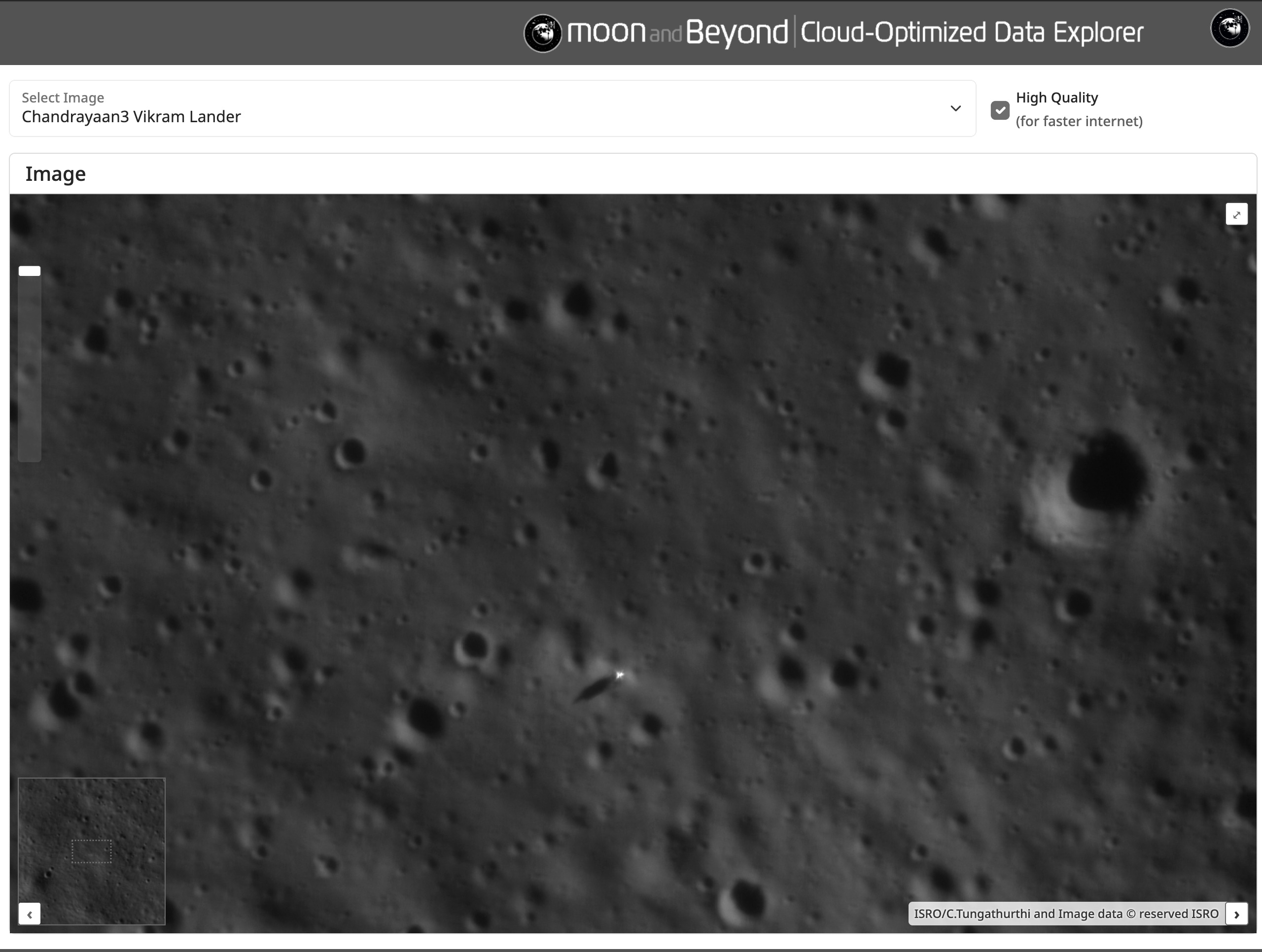
On this second anniversary, I want to open the doors to a bit of my workflow and share the joy with fellow “commoners.” Today, I’m releasing the Lunar Data Explorer—a portal optimized for “serving” the high-resolution lunar imagery (among others) made public by space agencies. Now, anyone can self-explore my curated data and “find” non-natural objects like the Chandrayaan-3 lander or Athena on their own, and share their findings with the world!
The primary goal of this portal is education. I want to give the general public the opportunity to explore and research for themselves. Naturally, all image copyrights remain with their respective owners. Please remember to always attribute the images and respect the original creators’ work. If you use the “Capture View” feature of the portal, the appropriate attribution will be displayed automatically.
I hope to keep releasing more curated content in the coming weeks and months. If you have a favorite dataset or suggestion, you’re welcome to leave a comment below this post—I’ll do my best to include it in an upcoming release slot. In the meantime, feel free to explore and enjoy the portal!
Below, you’ll find a short explainer on how to use the portal. Otherwise, it should be pretty straightforward. If you have any questions or comments, don’t hesitate to reach out. The portal is still in its early days, so there may be a few rough edges—some things might not work as expected. Suggestions are always welcome; I’ll do my best to address them. Leave a comment! 🙂
Cloud-Optimised Lunar Data explorer
The Lunar Data Explorer—or simply “Explorer”—is a straightforward, browser-based app that lets you explore high-resolution images captured by instruments like OHRC onboard Chandrayaan-2. Normally, working with these massive images can be a nightmare for your browser; it’s nearly impossible without hefty downloads! But Explorer is optimized specifically for a seamless browsing experience. What does that mean in practice? Instead of downloading an entire image strip (a typical high-res strip can easily exceed one and a half gigabytes!), the portal fetches only the portion you want to view—on the fly—while the rest of the image stays in low-res.
This is possible thanks to a browser-efficient image format that’s highly optimized for the cloud: Cloud-Optimized GeoTIFFs, or COGs for short. The technical details, specifications, and format intricacies deserve their own deep dive—I’ll save that for a future article where I’ll cover how I created the COGs for the lunar imagery in depth.
In short, Explorer serves these COGs, which power the entire portal. That’s why you can browse these images even over low bandwidth (trust me, I’ve tested it!). And, yes, for the data-hungry out there, there’s even a toggle to load higher-resolution images—if your internet connection can handle it.
How to Use the Explorer
While the usage is pretty straightforward, here are some features of the Explorer to help you get started:
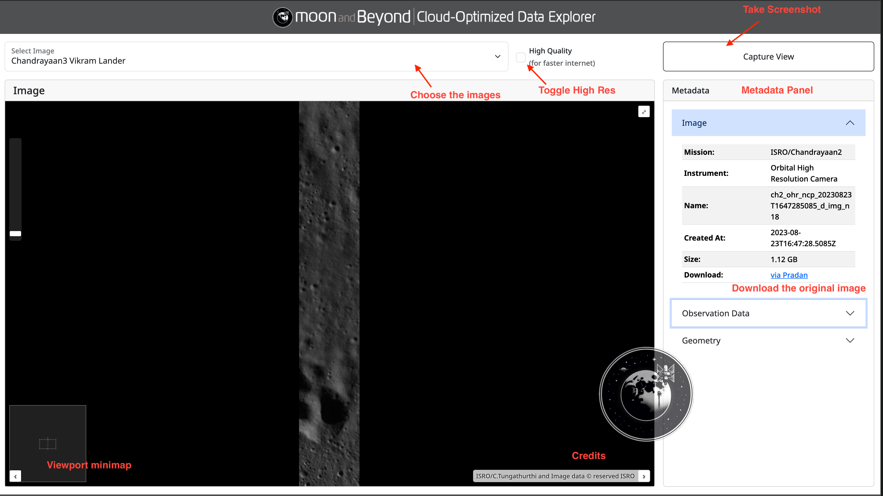
Select Image: At the top, you can choose from a list of available lunar images to explore—just use the dropdown menu.
Toggle High Quality: Switch on “High Quality” if you’ve got a faster internet connection and want to load images at higher resolutions.
Capture View: Use the “Capture View” button to take a screenshot of your current viewport; this will automatically include proper image attribution.
Viewport Minimap: The small panel at the bottom left acts as a minimap, helping you navigate and keep track of which section of the lunar image you’re viewing.
Metadata Panel: On the right, you’ll find detailed metadata for the current image—mission name, instrument, creation date, and filesize. You can also download the original image (eg: look for the “via Pradan” link).
Expanded Metadata: Additional data such as observation details and geometry can be accessed via expandable sections.
Credits: Image credits and attribution are always displayed to give proper recognition to source data and contributors.
Feel free to play around and explore—each feature is designed to make your lunar imagery journey as smooth and enjoyable as possible!
~FIN